3D Reconstruction
End to end Data Capture & Processing customized in order to deliver the best possible 3D content for Cultural Heritage Recording, Mapping, Ship and Industrial Infrastructure Inspection, Naval Architecture, Architecture, Virtual and Augmented Reality Experiences and Gaming.
A variety of 3D reconstruction technologies and techniques can be applied independently or in combination
Photogrammetry
For the 3D reconstruction of various objects we use terrestrial and large scale aerial images acquired by different platforms (balloons, UAVs etc). Automated computer vision techniques are combined with editing from experienced engineers in order to provide high quality results.
Laser Scanning
For medium and large sized objects laser scanning can be used to capture in detail the 3D geometry. Photogrammetry is usually applied in parallel for high quality texture mapping.
Structured Light Scanning
For small objects Structured Light Scanning is applied to ensure the correct recording of details.
Visual Quality and Geometric Accuracy
...from detailed small artefacts up to large geographic regions of interest...
Engine Room 3D Scanning
We perform 3D Scanning of Bulk Carriers Engine Rooms for Ballast Water Treatment System (BWTS) Retrofit.


Vessel 3D Scanning
We provide 3D Scannings of Vessels’ Hulls to Naval Architechts for Inspection, Analysis or Redesigning.

Real Estate
Buildings interior 3D Scanning
We provide 3D Scannings of Building Interiors to Architechts, Interior Designers, Real Estate Agencies, BIM Managers. We cooperate with higly skilled architects to produce blueprints and architectural drawings of appartments, villas, office buildings etc.


Buildings 3D Scanning
We can also capture hole buildings in 3D by means of drone mapping and 3D scanning. Besides 3D Models we can offer VR Virtual tours where we combine 3D geometry with 360 panoramas.
Cultural Heritage Recording
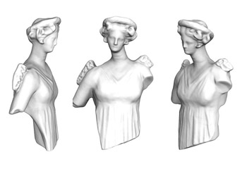
Small Artefacts
Small objects of cultural heritage, like statues and interesting details can be captured in high detail by means of structured light scanning or photogrammetry.


Architectural Details
Architectural details, like emblematic structures and decorations can be recorded in 3D through photogrammetry or laser scanning.
Archeological Sites
Photogrammetry and laser scanning can be applied in order to record large areas of interest like archeological sites, monuments, excavations or buildings.


End to end cultural heritage recording
We cooperate with some of the best Architects and Conservation Consultants, as Kosmas Skaris for the recording and interpretation of ruined monuments. This allows us to provide to our clients not only 3D models and orthophotos of high accuracy but also detailed architectural drawings.


Multiple Products
We can provide a big variety of digital products to the Architects, Archeologists and Conservationists, such as 3D mesh models, “true”orthophotos, drawings, “unfolded” views, VR Experiences or even 3D printed copies.


3D Mapping
Imagery from different sources can be processed and combined,
in order to deliver high quality geospatial products
Type of Imagery
- Terrestrial Images
- UAV images
- Digital Aerial Images
- Satelite Images
Products
- Textured or shaded 3D Mesh Models
- “True” Orthophotos
- Seamless Mosaics
- DTM/DSM or Point Clouds
- Vector Drawings
Application Scenario
Cadastre – Mapping
Update cadastre data with high resolution “true” orthophotos from drone imagery.


3D City Modelling
Fully 3D city models can be constructed from overlapping, large scale, digital aerial images.


UAV Mapping
The recent “boom” of UAVs is an opportunity to bring 3D Mapping to new applications.
Photogrammetric Surveying
High quality 3D geospatial data can be produced from typical digital aerial imagery.


